Point Stacker
The Point Stacker rendering transformation is a Vector-to-Vector transformation which displays a dataset with features that occur close together aggregated into a single point. This produces a more readable map in situations when there are many points to display. As the stacking is performed dynamically, it can be used to visualize changing data, and does not incur a performance overhead even when applied to very large datasets.
The stacked view is created by configuring a layer with an style which invokes the PointStacker rendering transformation.
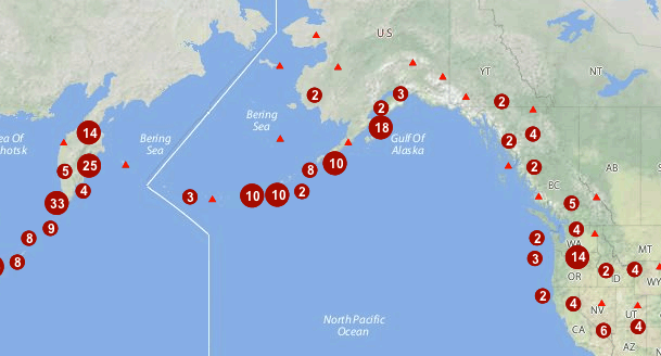
Point Stacker rendering transformation
Usage
As with all rendering transformations, the transformation is invoked by inserting a transform into a style. The style can then be applied to any layer which is backed by a suitable dataset.
The transformation function is called vec:PointStacker. Note that this is the same as the WPS process, as these functions can be invoked as either a WPS process or a rendering transformation.
The transformation parameters are as follows. The order of parameters is not significant.
| Name | Required? | Description |
|---|---|---|
data |
Yes | Input FeatureCollection containing the features to transform |
cellSize |
No | Size of the cells in which to aggregate points (in pixels, default = 1) |
outputBBOX |
Yes | Georeferenced bounding box of the output. Not required with YSLD. |
outputWidth |
Yes | Output image width. Not required with YSLD. |
outputHeight |
Yes | Output image height. Not required with YSLD. |
Environment variables as values
It is a common situation that the output image dimensions be determined by the client at rendering time, to allow for variable window sizes.
In these cases, it is possible to read in special environment variables to the rendering transformation.
There are three environment variables that will be useful to us, which can be used as values for the following input parameters:
| Environment variable | Description | Input parameter |
|---|---|---|
wms_bbox |
WMS request extent | outputBBOX |
wms_width |
Width of resulting image | outputWidth |
wms_height |
Height of resulting image | outputHeight |
The following YSLD syntax for employing environment variables is assumed by default and need not be added to the style:
outputBBOX: ${env(wms_bbox)}
outputWidth: ${env(wms_width)}
outputHeight: ${env(wms_height)}
The following SLD syntax for employing environment variables must be explictly declared:
<ogc:Function name="parameter">
  <ogc:Literal>outputBBOX</ogc:Literal>
  <ogc:Function name="env">
    <ogc:Literal>wms_bbox</ogc:Literal>
  </ogc:Function>
</ogc:Function>

<ogc:Function name="parameter">
  <ogc:Literal>outputWidth</ogc:Literal>
  <ogc:Function name="env">
    <ogc:Literal>wms_width</ogc:Literal>
  </ogc:Function>
</ogc:Function>

<ogc:Function name="parameter">
  <ogc:Literal>outputHeight</ogc:Literal>
  <ogc:Function name="env">
    <ogc:Literal>wms_height</ogc:Literal>
  </ogc:Function>
</ogc:Function>
Input
The PointStacker rendering transformation is applied to a dataset containing vector features. The features may be of any type, though point geometries are typically expected. If non-point geometries are used, the centroids of the features will be used. The dataset is supplied in the data parameter.
Output
The output of the transformation is a vector layer containing point features. Each feature has the following attributes:
| Name | Type | Description |
|---|---|---|
geom |
Point | Point geometry representing the group of features |
count |
Integer | Count of all input features represented by this point |
countUnique |
Integer | Count of all different input points represented by this point |
The output can be styled using a point symbolizer.
Examples
This example shows point stacking applied to a dataset of world volcanoes, displayed with a base map layer of continental topography.
The source data used in this example is the world:volcanoes layer (available for download on the Sample Data page).
Below are two examples showing how to perform this rendering transformation in both YSLD and SLD. You can adapt these examples to your data with minimal effort by adjusting the parameters.
YSLD
The PointStacker output, as seen in the figure at the top of the page, can be produced by the following YSLD:
1 2 3 4 5 6 7 8 9 10 11 12 13 14 15 16 17 18 19 20 21 22 23 24 25 26 27 28 29 30 31 32 33 34 35 36 37 38 39 40 41 42 43 44 45 46 47 48 49 50 51 52 53 54 55 56 57 58 59 60 61 62 63 64 65 66 | name: Default Styler
title: Stacked Point
abstract: Styles volcanoes using stacked points
feature-styles:
- name: name
transform:
name: vec:PointStacker
params:
cellSize: 30
rules:
- name: rule1
title: Volcano
filter: count <= '1'
symbolizers:
- point:
size: 8
symbols:
- mark:
shape: triangle
fill-color: '#FF0000'
- name: rule29
title: 2-9 Volcanoes
filter: count BETWEEN '2' AND '9'
symbolizers:
- point:
size: 14
symbols:
- mark:
shape: circle
fill-color: '#AA0000'
- text:
label: ${count}
fill-color: '#FFFFFF'
halo:
fill-color: '#AA0000'
fill-opacity: 0.9
radius: 2
font-family: Arial
font-size: 12
font-style: normal
font-weight: bold
placement: point
anchor: [0.5,0.8]
- name: rule10
title: 10 Volcanoes
filter: count > '9'
symbolizers:
- point:
size: 22
symbols:
- mark:
shape: circle
fill-color: '#AA0000'
- text:
label: ${count}
fill-color: '#FFFFFF'
halo:
fill-color: '#AA0000'
fill-opacity: 0.9
radius: 2
font-family: Arial
font-size: 12
font-style: normal
font-weight: bold
placement: point
anchor: [0.5,0.8]
|
This style defines the Point Stacker rendering transformation, providing values for the transformation parameters which are appropriate for the input dataset.
- On line 9, cellSize specifies a cell size of 30 to aggregate the points by.
Rules are applied to the transformation output to produce the rendered layer.
- Starting at line 11, the rule rule1 depicts a single (unstacked) point using a red triangle symbol.
- Starting at line 21, the rule rule29 depicts a stacked point which has a count in the range 2 to 9. The points are styled as dark red circles of size 14 pixels, with a label showing the count inside them.
- Starting at line 44, the rule rule10 depicts a stacked point which has a count of 10 or greater. The points are styled as dark red circles of size 22 pixels, with a label that includes the point count.
SLD
The PointStacker output can also be produced by the following SLD:
1 2 3 4 5 6 7 8 9 10 11 12 13 14 15 16 17 18 19 20 21 22 23 24 25 26 27 28 29 30 31 32 33 34 35 36 37 38 39 40 41 42 43 44 45 46 47 48 49 50 51 52 53 54 55 56 57 58 59 60 61 62 63 64 65 66 67 68 69 70 71 72 73 74 75 76 77 78 79 80 81 82 83 84 85 86 87 88 89 90 91 92 93 94 95 96 97 98 99 100 101 102 103 104 105 106 107 108 109 110 111 112 113 114 115 116 117 118 119 120 121 122 123 124 125 126 127 128 129 130 131 132 133 134 135 136 137 138 139 140 141 142 143 144 145 146 147 148 149 150 151 152 153 154 155 156 157 158 159 160 161 162 163 164 165 166 167 168 169 170 171 172 173 | <?xml version="1.0" encoding="ISO-8859-1"?>
<StyledLayerDescriptor version="1.0.0"
xsi:schemaLocation="http://www.opengis.net/sld StyledLayerDescriptor.xsd"
xmlns="http://www.opengis.net/sld"
xmlns:ogc="http://www.opengis.net/ogc"
xmlns:xlink="http://www.w3.org/1999/xlink"
xmlns:xsi="http://www.w3.org/2001/XMLSchema-instance">
<NamedLayer>
<Name>vol_stacked_point</Name>
<UserStyle>
<!-- Styles can have names, titles and abstracts -->
<Title>Stacked Point</Title>
<Abstract>Styles volcanoes using stacked points</Abstract>
<FeatureTypeStyle>
<Transformation>
<ogc:Function name="vec:PointStacker">
<ogc:Function name="parameter">
<ogc:Literal>data</ogc:Literal>
</ogc:Function>
<ogc:Function name="parameter">
<ogc:Literal>cellSize</ogc:Literal>
<ogc:Literal>30</ogc:Literal>
</ogc:Function>
<ogc:Function name="parameter">
<ogc:Literal>outputBBOX</ogc:Literal>
<ogc:Function name="env">
<ogc:Literal>wms_bbox</ogc:Literal>
</ogc:Function>
</ogc:Function>
<ogc:Function name="parameter">
<ogc:Literal>outputWidth</ogc:Literal>
<ogc:Function name="env">
<ogc:Literal>wms_width</ogc:Literal>
</ogc:Function>
</ogc:Function>
<ogc:Function name="parameter">
<ogc:Literal>outputHeight</ogc:Literal>
<ogc:Function name="env">
<ogc:Literal>wms_height</ogc:Literal>
</ogc:Function>
</ogc:Function>
</ogc:Function>
</Transformation>
<Rule>
<Name>rule1</Name>
<Title>Volcano</Title>
<ogc:Filter>
<ogc:PropertyIsLessThanOrEqualTo>
<ogc:PropertyName>count</ogc:PropertyName>
<ogc:Literal>1</ogc:Literal>
</ogc:PropertyIsLessThanOrEqualTo>
</ogc:Filter>
<PointSymbolizer>
<Graphic>
<Mark>
<WellKnownName>triangle</WellKnownName>
<Fill>
<CssParameter name="fill">#FF0000</CssParameter>
</Fill>
</Mark>
<Size>8</Size>
</Graphic>
</PointSymbolizer>
</Rule>
<Rule>
<Name>rule29</Name>
<Title>2-9 Volcanoes</Title>
<ogc:Filter>
<ogc:PropertyIsBetween>
<ogc:PropertyName>count</ogc:PropertyName>
<ogc:LowerBoundary>
<ogc:Literal>2</ogc:Literal>
</ogc:LowerBoundary>
<ogc:UpperBoundary>
<ogc:Literal>9</ogc:Literal>
</ogc:UpperBoundary>
</ogc:PropertyIsBetween>
</ogc:Filter>
<PointSymbolizer>
<Graphic>
<Mark>
<WellKnownName>circle</WellKnownName>
<Fill>
<CssParameter name="fill">#AA0000</CssParameter>
</Fill>
</Mark>
<Size>14</Size>
</Graphic>
</PointSymbolizer>
<TextSymbolizer>
<Label>
<ogc:PropertyName>count</ogc:PropertyName>
</Label>
<Font>
<CssParameter name="font-family">Arial</CssParameter>
<CssParameter name="font-size">12</CssParameter>
<CssParameter name="font-weight">bold</CssParameter>
</Font>
<LabelPlacement>
<PointPlacement>
<AnchorPoint>
<AnchorPointX>0.5</AnchorPointX>
<AnchorPointY>0.8</AnchorPointY>
</AnchorPoint>
</PointPlacement>
</LabelPlacement>
<Halo>
<Radius>2</Radius>
<Fill>
<CssParameter name="fill">#AA0000</CssParameter>
<CssParameter name="fill-opacity">0.9</CssParameter>
</Fill>
</Halo>
<Fill>
<CssParameter name="fill">#FFFFFF</CssParameter>
<CssParameter name="fill-opacity">1.0</CssParameter>
</Fill>
</TextSymbolizer>
</Rule>
<Rule>
<Name>rule10</Name>
<Title>10 Volcanoes</Title>
<ogc:Filter>
<ogc:PropertyIsGreaterThan>
<ogc:PropertyName>count</ogc:PropertyName>
<ogc:Literal>9</ogc:Literal>
</ogc:PropertyIsGreaterThan>
</ogc:Filter>
<PointSymbolizer>
<Graphic>
<Mark>
<WellKnownName>circle</WellKnownName>
<Fill>
<CssParameter name="fill">#AA0000</CssParameter>
</Fill>
</Mark>
<Size>22</Size>
</Graphic>
</PointSymbolizer>
<TextSymbolizer>
<Label>
<ogc:PropertyName>count</ogc:PropertyName>
</Label>
<Font>
<CssParameter name="font-family">Arial</CssParameter>
<CssParameter name="font-size">12</CssParameter>
<CssParameter name="font-weight">bold</CssParameter>
</Font>
<LabelPlacement>
<PointPlacement>
<AnchorPoint>
<AnchorPointX>0.5</AnchorPointX>
<AnchorPointY>0.8</AnchorPointY>
</AnchorPoint>
</PointPlacement>
</LabelPlacement>
<Halo>
<Radius>2</Radius>
<Fill>
<CssParameter name="fill">#AA0000</CssParameter>
<CssParameter name="fill-opacity">0.9</CssParameter>
</Fill>
</Halo>
<Fill>
<CssParameter name="fill">#FFFFFF</CssParameter>
<CssParameter name="fill-opacity">1.0</CssParameter>
</Fill>
</TextSymbolizer>
</Rule>
</FeatureTypeStyle>
</UserStyle>
</NamedLayer>
</StyledLayerDescriptor>
|
- Lines 15-43 define the Point Stacker rendering transformation, providing values for the transformation parameters which are appropriate for the input dataset.
- Line 18 specifies the input dataset parameter name.
- Line 21 specifies a cell size of 30 to aggregate the points by.
- Lines 24-42 define the output parameters outputBBOX, outputWith and outputHeight, which are obtained from internal environment variables set during rendering, as described above.
- Lines 44-169 define styling rules which are applied to the transformation output to produce the rendered layer.
- Lines 44-64 define a rule rule1 for depicting a single (unstacked) point using a red triangle symbol.
- Lines 65-119 define a rule rule29 for depicting a stacked point which has a count in the range 2 to 9. The points are styled as dark red circles of size 14 pixels, with a label showing the count inside them.
- Lines 120-169 define a rule rule10 for depicting a stacked point which has a count of 10 or greater. The points are styled as dark red circles of size 22 pixels, with a label that includes the point count.