Creating a process with a script
This tutorial will show how to create a script that creates a new WPS process. We will show bindings for Python here.
Process definition
This tutorial will create a process called “Distance and Bearing” with the following functionality: Given a feature collection and a single point, process will return a feature collection with the same number of elements as the source feature collection and with the same geometries, but with attributes containing the distance and bearing (angle of orientation) to the source point.
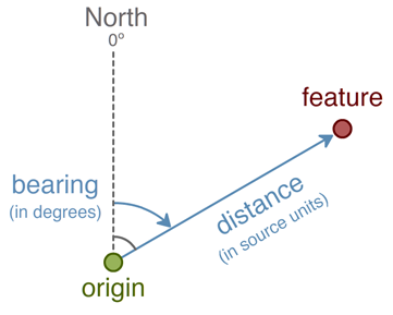
Distance and Bearing process
Distance is measured in the source units. Bearing will be an absolute bearing, in degrees measured from true north and increasing in the clockwise direction (so due east would be 90 degrees and due west would be -90 or 270 degrees).
While there is a distance function in both Python and JavaScript, the bearing will be calculated, measured from origin to point, according to the following:
Authoring the script
The complete script is as follows (Download):
:
import math
from geoserver.wps import process
from geoscript.geom import Point
from geoscript.feature import Feature
from geoscript.layer import Layer

@process(
  title = 'Distance and Bearing',
  description = 'Computes Cartesian distance and bearing from features to an origin.',
  inputs = {
    'origin': (Point, 'Origin from which to calculate distance and bearing.'),
    'features': (Layer, 'Features to which distance and bearing should be calculated.')
  },
  outputs = {
    'result': (Layer, 'Features with calculated distance and bearing attributes.')
  }
)
def run(origin, features):

  for f in features.features():
    p = f.geom.centroid
    d = p.distance(origin)
    b = 90 - math.degrees(math.atan2(p.y - origin.y, p.x - origin.x))

    yield Feature({'point': p, 'distance': d, 'bearing': b})
Save as distbear.py. A description of the script functionality follows.
Process headers
The script requires a number of import statements, including access to the GeoServer catalog, geometry and feature types, and WPS process hooks:
import math
from geoserver.wps import process
from geoscript.geom import Point
from geoscript.feature import Feature
from geoscript.layer import Layer
Process inputs and metadata
Next define the process inputs and metadata. Enclose all of these definitions in a process block:
@process(

)
Add a title and description for better readability:
  title = 'Distance and Bearing',
  description = 'Computes Cartesian distance and bearing from features to an origin.',
The process has two inputs, as described above: a feature collection (features), and a point from which to compute distance and bearing (origin). Create the inputs list with these two definitions, along with a description:
  inputs = {
    'origin': (Point, 'Origin from which to calculate distance and bearing.'),
    'features': (Layer, 'Features to which distance and bearing should be calculated.')
  },
The single output will return a feature collection, and is defined similarly:
  outputs = {
    'result': (Layer, 'Features with calculated distance and bearing attributes.')
  }
Process computation
Now that our inputs and outputs are defined, create the computation through a function called run.
Note that the schema for the layer will contain the identical point geometry as the source features, along with two attributes called distance and bearing.
The computation iterates over each of the features in our feature collection. Define the calculation as follows:
  for f in features.features():
    p = f.geom.centroid
    d = p.distance(origin)
    b = 90 - math.degrees(math.atan2(p.y - origin.y, p.x - origin.x))

    yield Feature({'point': p, 'distance': d, 'bearing': b})
where:
p–Point geometry of the layerd–Distance calculation from theoriginb–Angle measure clockwise from true north between origin and point.
These three variables as a list are then returned.
Activating the script
After the script is created, it must be added to GeoServer. Place the script in the GeoServer data directory in the location: <data_dir>/scripts/wps/. (Create this path if it doesn’t already exist.) The script will be activated automatically when copied to that location, with no server restart necessary.
Testing the script
Once the script is in place and activated, the next step is to test it. Use the WPS Request Builder in the GeoServer UI to verify this script’s functionality.
Access the WPS Request Builder in the GeoServer UI by clicking on Demos then WPS Request Builder.
Accessing the WPS Request Builder
Select the process in the menu. It will be named
py:distbear.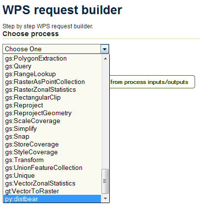
Scripts listed as WPS processes
The following values will work for testing:
Use the origin as our source point:
POINT(0 0)
Source features will consist of four points in the Cartesian plane:
POINT(1 0)
POINT(0 2)
POINT(-1 1)
POINT(6 3)
Converting these features from WKT into JSON yields the following:
{
  "type":"FeatureCollection",
  "features":[
    {
      "type":"Feature",
      "geometry":{
        "type":"Point",
        "coordinates":[
          1,
          0
        ]
      }
    },
    {
      "type":"Feature",
      "geometry":{
        "type":"Point",
        "coordinates":[
          0,
          2
        ]
      }
    },
    {
      "type":"Feature",
      "geometry":{
        "type":"Point",
        "coordinates":[
          -1,
          1
        ]
      }
    },
    {
      "type":"Feature",
      "geometry":{
        "type":"Point",
        "coordinates":[
          6,
          3
        ]
      }
    }
  ]
}
Fill out the form. Enter the above JSON in the box named features, making sure to select TEXT and application/json as the source format.
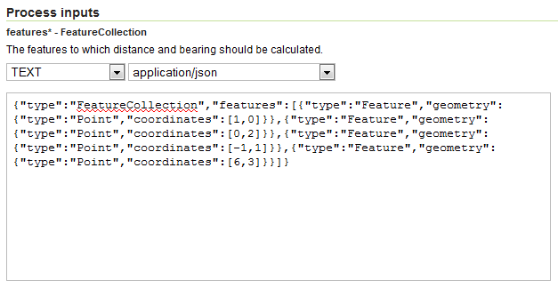
Input features
Then enter
POINT(0 0)in the box named origin, making sure to select TEXT and application/wkt as the source format.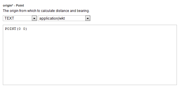
Origin point
Finally, select application/json as the output format under the Process outputs section.
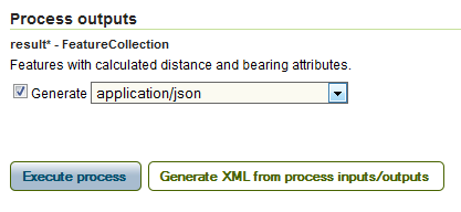
Result format
Click Execute process.
Note
If you are curious about what the actual process request looks like, click Generate XML from process inputs/outputs.
The process will execute. The output will look something like this:
{
  "type":"FeatureCollection",
  "features":[
    {
      "type":"Feature",
      "geometry":{
        "type":"Point",
        "coordinates":[
          6,
          3
        ]
      },
      "properties":{
        "distance":6.708203932499369,
        "bearing":63.43494882292201
      },
      "id":"fid--ad4a787_1394a31a374_-7bba"
    },
    {
      "type":"Feature",
      "geometry":{
        "type":"Point",
        "coordinates":[
          -1,
          1
        ]
      },
      "properties":{
        "distance":1.4142135623730951,
        "bearing":-45.0
      },
      "id":"fid--ad4a787_1394a31a374_-7bb8"
    },
    {
      "type":"Feature",
      "geometry":{
        "type":"Point",
        "coordinates":[
          0.0,
          2
        ]
      },
      "properties":{
        "distance":2.0,
        "bearing":0.0
      },
      "id":"fid--ad4a787_1394a31a374_-7bb6"
    },
    {
      "type":"Feature",
      "geometry":{
        "type":"Point",
        "coordinates":[
          1,
          0.0
        ]
      },
      "properties":{
        "distance":1.0,
        "bearing":90.0
      },
      "id":"fid--ad4a787_1394a31a374_-7bb4"
    }
  ]
}
Or, in a more compact representation:
X Y Distance Bearing 1 0 1.0 90.0 0 2 2.0 0 -1 1 1.41 -45.0 6 3 6.71 63.43 Graphically:
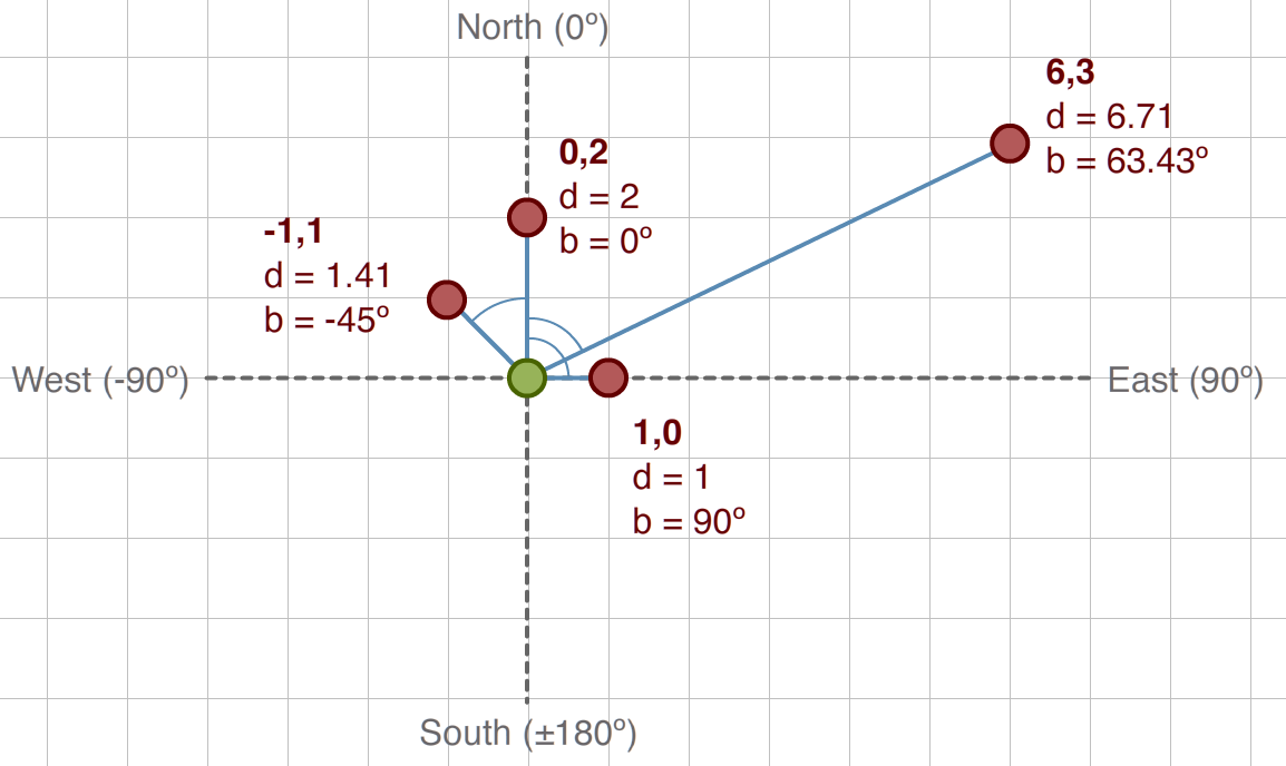
Distance and Bearing example